Tilicho Lake (world Highest) Trek |
|
Tilicho Lake Trek Nepal
Tilicho lake Trek information
The Tilicho Lake and Thorong La Pass trek is a challenging and exhilarating adventure for trekkers seeking a unique experience in the Annapurna region of Nepal. The trail offers awe-inspiring views of towering snow-capped peaks, alpine forests, and picturesque valleys.
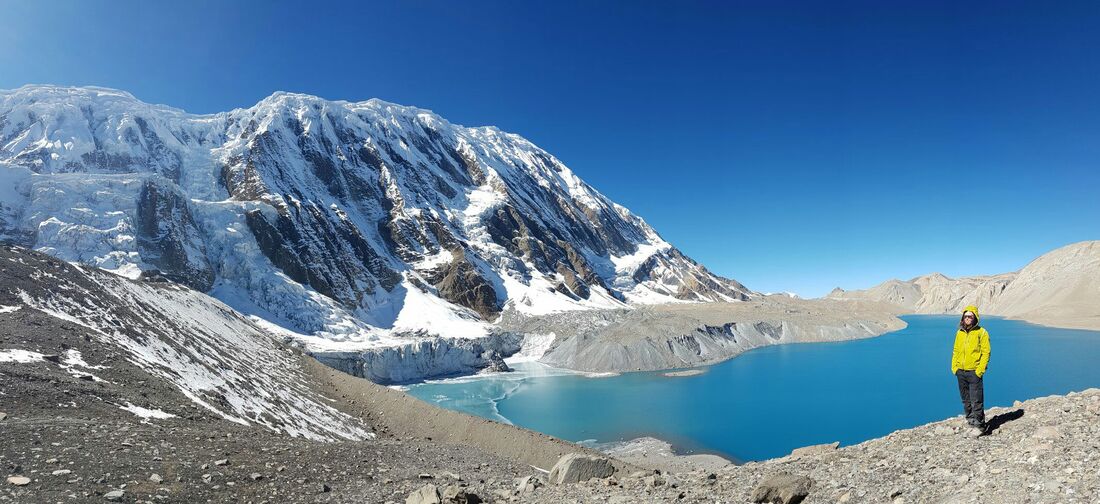
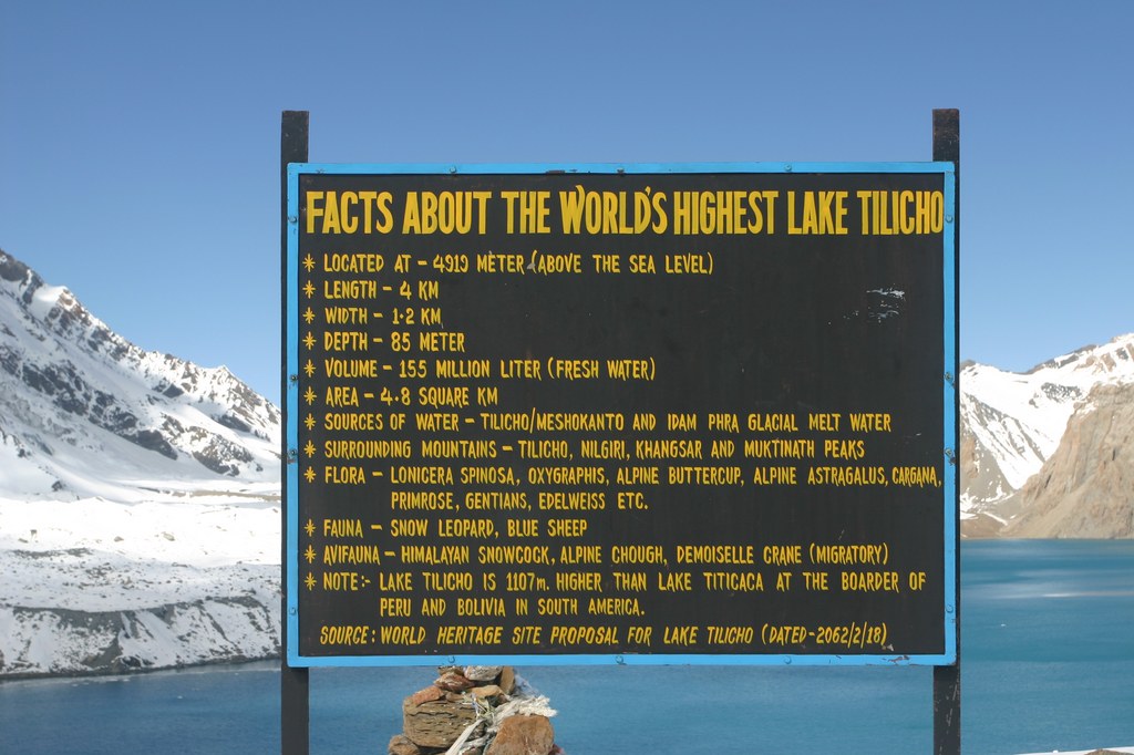
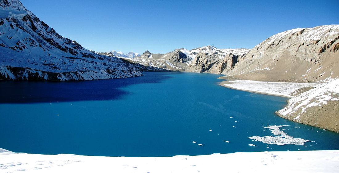
The highlight of this trek is the visit to Tilicho Lake, situated at an altitude of 4,919 meters. It is one of the highest lakes in the world, surrounded by breathtaking views of the Annapurna and Gangapurna mountain ranges. The deep turquoise color of the lake against the backdrop of rugged Himalayan landscapes makes for an unforgettable sight.
The trek also includes crossing the Thorong La Pass, standing tall at 5,416 meters. This is one of the highest points on the Annapurna Circuit trek and offers stunning panoramic views of the Annapurna and Dhaulagiri mountain ranges. The pass marks the transition between the Manang and Mustang regions, allowing trekkers to experience the unique cultural traditions and hospitality of the local communities.
The trek requires a moderate to high level of physical fitness, as well as acclimatization to the high altitude. Proper planning, including a rest day in Manang for acclimatization, is essential to ensure a safe and enjoyable trekking experience. The best time to undertake this trek is during the spring (March to May) or autumn (September to November) seasons when the weather is generally favorable and the views are at their best.
The Tilicho Lake and Thorong La Pass trek is a challenging and exhilarating adventure for trekkers seeking a unique experience in the Annapurna region of Nepal. The trail offers awe-inspiring views of towering snow-capped peaks, alpine forests, and picturesque valleys.
The highlight of this trek is the visit to Tilicho Lake, situated at an altitude of 4,919 meters. It is one of the highest lakes in the world, surrounded by breathtaking views of the Annapurna and Gangapurna mountain ranges. The deep turquoise color of the lake against the backdrop of rugged Himalayan landscapes makes for an unforgettable sight.
The trek also includes crossing the Thorong La Pass, standing tall at 5,416 meters. This is one of the highest points on the Annapurna Circuit trek and offers stunning panoramic views of the Annapurna and Dhaulagiri mountain ranges. The pass marks the transition between the Manang and Mustang regions, allowing trekkers to experience the unique cultural traditions and hospitality of the local communities.
The trek requires a moderate to high level of physical fitness, as well as acclimatization to the high altitude. Proper planning, including a rest day in Manang for acclimatization, is essential to ensure a safe and enjoyable trekking experience. The best time to undertake this trek is during the spring (March to May) or autumn (September to November) seasons when the weather is generally favorable and the views are at their best.
Fact About Tilicho Lake Trek
- Location: Tilicho Lake is located in the Manang district of Nepal, situated at an altitude of about 4,919 meters . It is one of the highest lakes in the world.
- Trek Difficulty: The Tilicho Lake trek is considered to be a challenging trek due to its high altitude and steep terrains. Proper physical fitness and acclimatization are necessary for this trek.
- Trek Duration: The trek to Tilicho Lake usually takes around 10-15 days, depending on the route and itinerary chosen. It can be combined with the popular Annapurna Circuit trek for a longer adventure.
- Permits: To trek in the region, you need to obtain the Annapurna Conservation Area Permit (ACAP) and the TIMS (Trekkers' Information Management System) card. These permits can be obtained in Big Sky Treks Nepal
- Starting Point: The trek to Tilicho Lake usually starts from Besisahar or Chame, which are accessible by road from Kathmandu or Pokhara. From there, the trail leads to Manang village and further to Tilicho Base Camp.
- Trail Highlights: The trek offers breathtaking views of snow-capped mountains, including Annapurna range, Dhaulagiri, and Tilicho Peak. It involves crossing suspension bridges, passing through dense forests, and exploring traditional Nepalese villages.
- Accommodation: Along the trekking route, there are tea houses and lodges where trekkers can stay. These basic accommodations provide rooms with beds and shared bathroom facilities. It is advisable to carry a sleeping bag for extra warmth.
- Altitude Sickness: Due to the high altitude, altitude sickness can be a concern. It is crucial to take proper acclimatization breaks, stay hydrated, and listen to the guidance of the trekking team or guides.
- Weather: The best time to trek to Tilicho Lake is during the months of March to May and September to November when the weather is relatively stable. Winter months (December to February) can be extremely cold, and monsoon season (June to August) brings heavy rain and unfavorable trekking conditions.
- Trekking Guide: Hiring a licensed trekking guide or joining a guided tour is recommended for a safe and hassle-free trek to Tilicho Lake. An experienced guide can provide valuable information, ensure your safety, and assist in case of any emergencies.
Note: It is always good to be well-prepared with necessary trekking gear, including proper clothing, trekking boots, a backpack, first aid kit, and other essentials. It is also advisable to carry some cash, as ATMs may not be available along the trekking route.
Fact About Tilicho Lake Trek
Outline itinerary of Tilicho lake Trek
Outline itinerary of Tilicho lake Trek
Day 1: Arrival in Kathmandu (1,400m)
Day 2: Kathmandu city tour and trek Preparation
Day 3: Drive from Kathmandu to Besisahar (760m)
Day 4: Jeep Drive from Besisahar to Chame (2650m)
Day 5: Trek from Chame to Pisang (3250m)
Day 6: Trek from Pisang to Manang (3540m)
Day 7 : Acclimatization day in Manang
Day 8: Trek from Manang to Shree Kharka (4080m)
Day 9: Trek from Shree Kharka to Tilicho lake base camp (4150m)
Day 10: Trek from Tilicho Base camp to Tilicho Lake (4920m) and trek back to base camp
Day 11: Trek from Tilicho base camp to Yak Kharka (4050m)
Day 12: Trek from Yak Kharka to Thorong Phedi (4550)
Day 13: Trek from Thorong Phedi to Muktinath (3800m ) cross Thorong La pass (5416m)
Day 14: Drive from Muktinath to Pokhara (2800m)
Day 15: Trek from Kagbeni to Marpha (2670m)
Day 16: Pokhara Free day
Day 17: Drive or flight from Pokhara to Kathmandu
Day 18: Departure from Kathmandu to home
Detail Itinerary of Tilicho lake
Detail Itinerary of Tilicho lake Trekking Route
Day 1: Arrival in Kathmandu (1,400m)
Day 8: Trek from Manang to Shree Kharka (4080m) (8Km, 6Hrs )
Day 1: Arrival in Kathmandu (1,400m)
- Arrive at Tribhuvan International Airport in Kathmandu
- Transfer to your hotel and rest
- Explore UNESCO World Heritage Sites in Kathmandu, such as Pashupatinath Temple, Boudhanath Stupa, Swayambhunath and Kathmandu Durbar Square
- Obtain necessary trek permits and equipment
- The drive offers breathtaking views of terraced fields, green hills, and mountain peaks. There are viewpoints to capture stunning photos of valleys, rivers, and forests.
- Besisahar is a starting point for the Annapurna Circuit trek and offers accommodations and amenities, giving tourists a taste of local hospitality and a chance to prepare for their adventure.
- The drive from Besisahar to Chame offers breathtaking views of the Annapurna mountain range, providing trekkers with a preview of the stunning landscapes.
- The road is an adventurous and off road experience, with narrow cliff-side paths.
- The drive allows trekkers to acclimatize to the altitude gradually, as Chame, making it an ideal starting point for the Annapurna Circuit trek.
- After leaving Chame Village, we cross the Marshyangdi river, enter pine forests, and pass through the Bratang village and a large cliff.
- We cross rocky and cliffy paths, cross the Marshyangdi river again, and climb to Dhukur Pokhari.
- From Dhukur Pokhari, we walk on a flat path and reach Pisang, where we are rewarded with breathtaking views of the Annapurna Himalayas range and Pisang Peak (6091m).
- From Pisang to Manang, trekkers have the option of taking the lower or higher route.
- The lower route is easier and recommended for porters. It involves passing through Humde village, following a flat path to Braga and Manang. Beautiful scenery of Pisang Peak (6091m), Tilicho Peak (7134m), and the Annapurna Himalayas range can be seen along the way.
- The higher route is more challenging and recommended for guides and guests. After crossing the Suspension Bridge, trekkers climb up to Gharu (3700m), which offers panoramic views. Continuing to Ngawal (4000m), trekkers can enjoy stunning views of Annapurna II (7937m), Annapurna IV (7525m), Pisang Peak (6091m), Tilicho Peak (7134m), Tilicho Valley, Gangapurna (7455m), and traditional houses. The route then goes down to Munji, where it intersects with the lower route and leads to Bragha (3450m) and finally Manang.
- Manang village is a popular stop for acclimatization, offering beautiful views of the Annapurna Himalayan range.
- Manang is a popular acclimatization spot along the Annapurna Circuit trek in Nepal. It is located at an altitude of around 3,500 meters, and spending a day here helps trekkers adjust to the higher altitude and reduce the risk of altitude sickness.
- The acclimatization day in Manang provides trekkers with an opportunity to explore the town and visit the nearby Gangapurna Lake and Ice Lake. These excursions not only offer breathtaking views but also allow trekkers to gradually increase their altitude and build endurance.
- In addition to physical acclimatization, this day serves as an information session for trekkers. They can attend lectures or discussions on high altitude sickness prevention and treatment, as well as learn about the upcoming challenging sections of the trek, ensuring a safer and more successful journey.
Day 8: Trek from Manang to Shree Kharka (4080m) (8Km, 6Hrs )
- The trail from Manang to Shree Kharka on the way to Tilicho Lake Trek is a scenic and adventurous journey, passes khangshar village
- The trek offers breathtaking views of snow-capped mountains, lush valleys, and alpine landscapes.
- With varying terrain and altitudes, trekkers can expect a moderate to challenging hike.
- When trekking from Shree Khakra to Tilicho Lake Base Camp, it is essential to be cautious of falling rocks, as the presence of bluesheep and strong winds can trigger rockfalls.
- The trail is known for its challenging rocky terrain, requiring careful navigation.
- Despite the risks, trekkers are rewarded with breathtaking views of the majestic Himalayan mountains, making the journey worth it.
- The trek from Tilicho Base Camp to Tilicho Lake involves navigating a rocky trail with a challenging and steep climb up.
- The physical exertion and difficulties along the way are quickly forgotten upon reaching Tilicho Lake, as it offers a mesmerizing view that makes all the pain worthwhile.
- Trekkers can take time to appreciate the beauty, capture the breathtaking scenery in photographs, and then make their way back to base camp following the same trail.
- Starting from Tilicho Base Camp, trekkers can venture towards Yak Kharka, following the same path until Shree Kharka.
- Along the way, they will be treated to breathtaking views of Annapurna himalayas range and the surrounding landscapes. Enjoy the sight of large yaks grazing in the area.
- On this day, we will be joining the famous Annapurna Circuit Trek in Yak Kharka.
- The trek from Yak Kharka to Thorong Phedi takes you through a picturesque trail, offering stunning views of the surrounding mountains and landscapes.
- Traverse through picturesque landscapes, offering stunning views of the surrounding mountains, including Annapurna and its neighboring peaks.
- Reach Thorong Phedi, a key resting point before the challenging Thorong La Pass, where trekkers prepare for the next leg of their journey.
- The trek from Thorong Phedi to Muktinath involves a challenging climb up to Thorong La Pass, standing at a breathtaking.
- Trekkers typically start early in the morning to give themselves enough time to navigate the steep ascent to the top of Thorong La Pass.
- After reaching the pass, trekkers descend to Muktinath, a sacred place revered by both Hindus and Buddhists, known for its ancient temples and natural beauty.
- As you drive from Muktinath to Pokhara, you will follow the majestic Kaligandaki River, passing through picturesque villages such as Kagbeni Jomsom, Marpha, and Tukuche.
- These villages offer stunning mountain views, traditional architecture, and a chance to experience the local culture.
- On the route, you can also visit natural hot springs, where you can relax and rejuvenate before reaching the beautiful city of Pokhara
- Explore the city with a guided tour, visiting attractions like the Old Bazaar, Tal Barahi Temple, and Davis Falls Gupteshwor Mahadev Cave, Bindabasini temple and many more
- Indulge in the thrilling experience of paragliding and soar above the stunning landscape of Pokhara.
- Enjoy a serene boating experience on Phewa Lake, surrounded by beautiful mountains.
- Relax and unwind at one of the lakeside spas, pampering yourself after the challenging trek.
- Visit the International Mountain Museum to learn about the Himalayan region's culture and mountaineering history.
- Witness the breathtaking sunrise or sunset from the popular viewpoint, Sarangkot, for captivating scenic views.
- Take a scenic flight from Pokhara to Kathmandu and enjoy panoramic views of the Himalayas and the stunning landscape below.
- Alternatively, a road trip from Pokhara to Kathmandu, enjoying the picturesque surroundings and the chance to stop at various viewpoints and attractions along the way.
- We Have farewell dinner in Nepali Culture restaurant
- According to your Flight schedule we drop of your final departure to your home or next destination.
Included and Exclude in Tilicho Lake Trek
Included and Exclude in Tilicho Lake Trek
Include
Exclude
Include
- Airport / Hotel / Airport transfers by private vehicle
- Kathmandu Hotel with breakfast
- Experience trekking guide
- Porters (1 porter for between 2 trekkers basis)
- Duffel Bag (If you needed) (please let us know before you book the trip and remind us in kathmandu)
- Trekking Route Map (For Group Leader )
- Annapurna Conservation Area Trekking Permit
- Trekker’s information management system (TIMS) card fee
- Pokhara - Besisahar by Local bus ( Private car or flight available by adding extra cost)
- Pokhara hotel with breakfast
- Food and Accommodation during the trekking in Tea house
- Muktinath to Pokhara transport by bus ( Private jeep or flight from Jomsom (1 day extra) available by adding extra cost)
- Farewell Nepali dinner in Kathmandu
- All necessary paper works, office service charge and all Government Taxes
Exclude
- Nepal entry visa fee, you can get Nepal visa upon arrival at the Airport.
- Lunch and dinner in Kathmandu & Pokhara.
- International Airfare/Airport tax,
- City tour ( Vehicle and Entry fee ) we can manage it if you are interesting
- Alcoholic, hot and cold drinks, hot shower, Mineral/ hot water, desserts.
- Personal expenses such as laundry, telephone calls, sweets, snacks, beverages and bar bills, camera battery charging.
- Travel Insurance (Essential – Should include emergency evacuation coverage while trekking up to 5500+ meters).
- Personal trekking gears,
- Local jeep and Bus transport if use in between the trekking route (not Mention in itinerary)
- Tips for tour/ trekking staffs and driver
we would like to inform everyone that we have the original trekking route for the Tilicho Lake Trek. Nowadays, due to the existence of a highway, it is possible to complete the trek in a shorter time period. If you are interested in a customized itinerary, we kindly request that you reach out to us either through the email address [email protected] or contact us directly at +9779846139572.
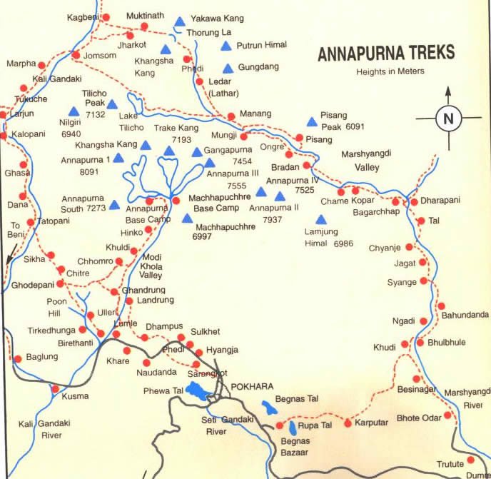
Annapurna circuit and tilicho lake trek map
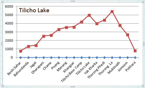
Annapurna circuit and tilicho lake trek profile chart
Note:
Check the Standard Itinerary in the bottom of the Page
Before starting This trek we have some option please check the option
Option
After Throng la Pass we have Many Option Please all things are depends on your interesting and depends on your Holiday
Check the option
When we arrive in Muktinath we have different Choice for You so all the choice are given Below
Option From Muktinath
Option
- Overnight stay in Besisahar and following day Drive to Chame
- Follow the Standard Itinerary
After Throng la Pass we have Many Option Please all things are depends on your interesting and depends on your Holiday
Check the option
When we arrive in Muktinath we have different Choice for You so all the choice are given Below
Option From Muktinath
- Same Day Take Jeep/Bus to pokhara
- Trek to Kagbeni and continue via Jomsom next day
- Trek direct to Jomsom and fly Pokhara next day
- Take Jeep/Bus to Jomsom and fly next Day
- Take Jeep/Bus to Pokhara
- Take Bus/Jeep to Tatopani and continue trekking to Ghorepani Poon Hill
- Take Bus/Jeep to Tatopani and Stay overnight there and Next day drive to beni and pokhara
- Continue the classic route trekking for 4 days walk due to frequent passing vehicles on the route between Muktinath to Tatopani , views are still incredible.
- Trek to Nayapool same day and drive to pokhara
- Trek to Hile and next day nayapool and drive to Pokhara
- Trek to Ghandruk and Next day Pokhara
- Trek to Annapurna Base Camp Trekking route
- Trek to Jhinu dada and Next day Pokhara
- Trek to Ghandruk and Next day Pokhara
- Trek to Nayapool and drive to Pokhara
- Trek to Tolka , Dhampus and Phedi and drive to Pokhara
You may like also this Trip in Nepal :
👣Everest Region Trek: ⛰Everest Base Camp (EBC) ⛰Chola pass ⛰ 3 passes Trek ⛰Gokyo lake (Gokyo Ri)
👣Annapurna Region Trek: ⛰Annapurna Base Camp (ABC) ⛰Ghorepani Poonhill ⛰Jomsom Muktinath
⛰Tilicho Lake ⛰Round Annapurna ⛰Mardi Himal
👣 Langtang Region Trek : ⛰Langtang Trek ⛰Gosaikunda Trek ⛰Langtang Gosaikunda
👣Manaslu Region Trek: ⛰Manaslu Circuit
👣Other Activities in Nepal: ⛰Rafting ⛰Paragliding ⛰Jungle Safari ⛰Bungee Jump ⛰Mountain Flight
⛰Heli tour ⛰Zip Fly ⛰Short Hike ⛰City Tour
👣Useful Info : ⛰Nepal Info ⛰About Trek ⛰Weather and climate ⛰High altitude sickness ⛰Trekking season ⛰Trekking Equipment ⛰Training ⛰Tims card ⛰First Aid Kits ⛰Trekking grade ⛰Trekking Tips ⛰Use Trekking pole ⛰Types of Trekking, ⛰Trekking Documents
👣Blogs And Updates: ⛰Nepal travel blog ⛰BST Blog ⛰TripAdvisor blog
👣Social Media: ⛰TripAdvisor page ⛰Google Map ⛰Facebook ⛰Instagram
⛰Site map ⛰Home Page 🏠
👣Contact Details: Big Sky Treks Nepal 📧 : ⛰ [email protected] ⛰ [email protected]
👣WhatsApp/ Line/ Telegram/ WeChat / Phone 📱: +977-9846139572
Free Tour Consult with Expert
📞+9779846139572
©️Big Sky Treks
Classical Tilicho Lake Trek and Annapurna circuit Trek Nepal
Day by Day itinerary
Day 01: Arrival in Kathmandu (1,400m)
Day 02: Kathmandu Sightseeing and trek Preparation
Day 03: Drive Kathmandu to Besishahar (800m)
Day 04 : Nadi to Jagat (1,300m.)
Day 05: Jagat to Dharapani (1900m.)
Day 06: Dharapani to Chame (2710m)
Day 07: Chame to Pisang (3250m)
Day 08: Pisang to Manang (3540m)
Day 09: Acclimatization day in Manang
Day 10: Manang to Khangsar village (3734m)
Day 11: Khangsar Village to Tilicho lake base camp (4150m)
Day 12: Tilicho Base camp to Tilicho Lake (4920m) and trek
Day 13: Tilicho base camp to Yak Kharka (4050m)
Day 14: Yak Kharka to Throng Phedi (4550)
Day 15: Throng Phedi - Thorong La pass (5416m)and Muktinath (3800m )
Day 16: Muktinath to Kagbeni (2800m)
Day 17: Kagbeni to Marpha (2670m)
Day 18: Marpha to Kalopani (2550m)
Day 19: Kalopani to Tatopani (1200m)
Day 20: Tatopani to Ghorepani
Day 21: Ghorepani to Poon Hill(3210m) and Trek to Tadapani (2540m)
Day 22 : Tadapani to Ghandruk ( 1990m)
Day 23: Ghandruk to Nayapul and Drive to Pokhara
Day 24: Pokhara Free day
Day 25: Drive Pokhara to Kathmandu
Day 26: Departure
Details Itinerary of Tilicho lake Treks
Day 01: Arrival in Kathmandu (1,400m)
Upon arrival at the airport, meet and transfer to the hotel. In the afternoon, you have an option to be escorted stroll around Thamel and the local streets of Kathmandu.
Day 02: Kathmandu Sightseeing and trek Preparation
After breakfast, start sightseeing covering the UNESCO World Heritage sites in Kathmandu, which are Kathmandu Durbar Square and Swayambhunath Stupa. Kathmandu Durbar Square area holds the palaces of the medieval Kings who ruled over the Kathmandu Kingdom. Swayambhu meaning the “the self-existent” is popular among the foreigners as Monkey Temple owing to the large number of monkey population residing in this area. It is said that Swayambhunath Stupa is more than 2,000 years old, and it symbolizes knowledge. The painted eyes on all four sides symbolize the all-seeing power of Buddha. It is an important Buddhist place where pilgrims from all over the world come. In the afternoon you will get short briefing and discussion regarding your trek
Day 03: Drive Kathmandu to Besishahar (800m) , Drive to Bulbule and Trek to Nadi ( 890m)
Distance 188 kms and 4 km walk – Approximately 7 Hours Drive and 1 hour walk
We will start our trip early Morning as we will drive Vehicle along the trishuli river and after Mugling we follow Marshyangdi river and we will reach in Besisahar. After that we will change another bus to Bulbule and start to trek for Nadi While travelling, we will see beautiful green hills and Annapurna Himalayas range We can see also beautiful small villages, greeneries, farms, people doing their daily choirs, etc. We can see those views throughout travelling. From Besisahar if we start to trek we can also it take another hour extra. Nadi is a small village suited in bank of Marshyangdi river
Day 04 : Nadi to Jagat (1,300m.)
Trekking distance 12 km approximately 6 Hours walks.
We will pass some beautiful village and local people same time we will pass some suspension bridge and passing few spectacular waterfalls. we will reach Bahundanda ( 1310m). After that the trail descend through the terraced, rice fields and small streams until we reach Syange. After Syange the path ascends steeply and brings us to Jagat village where Tamang and Gurung are the main inhabitants. One the way, we can see Mt. Lamjung (6983m)Manaslu (8156m) and Peak 29 known as Nadi chuli (7871m)
Day 05: Jagat to Dharapani (1900m.)
Trekking distance 15 km approximately 7 Hours walks.
From Jagat the trail descends to the Marsyangdi following the riverbank before climbing up through forests to Chamje (1430m) we can see beautiful Water fall . The trail initially crosses the river to the east bank and climbs up to the large settlement of Tal , which is first village of Manang District From Tal we can see beautiful waterfall. Crossing and recrossing the river as it makes its way to Karte, the trail finally crosses again to the west bank before continuing through the village of Dharapani
Day 06: Dharapani to Chame (2710m)
Trekking distance 16 km approximately 7 Hours walks
From Dharapani we will passes some beautiful village which are suited in bank of Marshyangdi River when we arrive in Danaque the trail starting climbing uphill through the forests of rhododendron and oak with beautiful views of Manaslu (8154m) on the back. Upon reaching Timang Danda we will have spectacular views of the Himalayas. And we will walk towards Chame passing small villages like Talamarang, Thanchok and Koto. Chame is district headquarters of Manang This place will serve magnificent views of Annapurna II(7,937) and Lamjung Himal (6,932) ahead of us, and Manaslu (8,154) and Ngadi Chuli (7,871) behind us
Day 07: Chame to Pisang (3250m)
Trekking distance 13 km approximately 6 Hours walks
End of the Chame Village we will cross Marshyangdi river and enter the forests of pines. The trail enters inside small valley with gentle ups. We will then meet Bratang village from there we can see really huge cliff and after cross the rocky and Cliffy path again we will cross the Marshyangdi river and climb up and reach Dhukur Pokhari. From Dhukur Pokhari we will walk flat and we reach Pisang where spectacular views of Annapurna Himalayas range and Pisang Peak (6091m)
Day 08 Pisang to Manang (3540m)
Trekking distance 19 km approximately 9 Hours walks Upper trail
Trekking distance 15 km approximately 6 Hours walks Lower Trail
From Pisang to Manang we offers a choice in trails
1) Lower Route ( Suggest for Porter )
It is very easy route little little climb up and cross the Humde village where we can see airport and continue follow the flat way we will arrive in Braga and Manang ( suggest our porter will follow the lower route so manage your necessary things we will meet our porter in Manang ) according to your interested we can follow the lower route , we can see beautiful scenery of Pisang peak(6091m, Tilicho peak(7134m) and Annapurna Himalayas range
2) Higher Route ( Suggest for guide and Guest )
The Higher route is quite top route , after pass the pine forest we cross the Suspension bridge and start to climb up to Gharu (3700m) is a beautiful view point and chorten from where we can see lower route of manang , we continue walk onward to Ngawal (4000m) villages. on the way we can see amazing view of Annapurna II (7937m) , Annapurna IV(7525m), Pisang peak (6091m) , Tilicho Peak (7134m) ,Tilicho valley Gangapurna (7455m) and Very old style house and local people . After Ngawal village continue down to Munji where we can Meet lower route and cross Bragha (3450m) and arrive in Manang ,
Manang village is one of the most popular villages of Annapurna circuit trekking route . This village is an acclimatization stop point for every travelers. Situated in front of the beautiful Annapurna Himalayan range,
Day 09 : Acclimatization day in Manang
Today is the schedule for acclimatization. However, we do not spend worth less at the lodge. It is highly suggested to climb up and stay overnight at low altitude so our body can adjust the high altitude climate. from manang we can choose any one of them for a day trip
In Afternoon Himalayan Rescue Association (HRA) provide altitude lectures for the trekkers and it will be worth attending one of those lectures. They give some useful tips on how to battle through the next 3 days to Thorung La pass. They will also explain the acclimatizing principle of "climb high and return to sleep in the low".
Gangapurna Glacier viewpoint /Chongar Viewpoint/ Gangapurna Tea shop
From the main Village we drop around 15 minute and cross the Marshyangdi River and Continue climb up to Chongar Viewpoint, quite steep but amazing 360 degree views from the top. Recommended especially if you're not visiting Ice Lake or Tilicho Lake.
Visiting Praken Gompa /100 rupees lama (3945 m)
Praken Gompa just 400 m above the manang Village where one old monk Tashi Lama stay there and give the blessing for Trekkers for successful of throng la pass. It was really a great experience no one could forget it. From Praken Gompa we can see beautiful views of the Annapurna Himalayas range and Tilicho peak . This trip also perfect for acclimatization.
Ice Lake (4620m)
One of the most impressive viewpoints on the Annapurna circuit trekking routr is Ice Lake (Kicho Tso, 4620m). It takes about 5 hours to climb 1000m from Manang Village , it’s straight uphill the whole way to the Lake which is considered sacred by Buddhists.
Day 10: Manang to Khangsar village (3734m)
Trekking distance 6 km approximately 4 Hours walks
Descending from old Manang and passing by Chorten reach a Marsyangdi river, cross a suspension bridge over Jharsing Khola (stream It is possible to cross the ridge north of Annapurna IV, II, and Glacier Dome or to descend from village to the glacial lake at the foot of a huge icefall descending from the northern slopes of Gangapurna. The trail stays close to the river bed and soon we approach Khangsar, superb view of the Great Barrier open up. Where we can find a small monastery, chorten, Mani walls and prayer flags.
Day 11: Khangsar Village to Tilicho lake base camp (4150m)
Trekking distance 8 km approximately 5 Hours walks
From Khangsar the trail climbs steeply past the Gompa and small chortens, trail goes through juniper and sea buckthorn bushes. The path is quite covered by small crystals and shrubs can be seen on both sides. Some places along the trail you cross a few streams.You reach a crest (4650m) with prayer flags after the wearying clim and then through a series of zigzags down a scree slope bring you to the Tilicho Base Camp Hotel. From here you can enjoy the closer and panoramic views of Tilicho Mountain and many others. Tilicho Lake is situated at the highest altitude so we set our camp today here at low.
Day 12: Tilicho Base camp to Tilicho Lake (4920m) and trek back to base camp
Trekking distance 12 km approximately 8 Hours walks ( both way )
The trail to the Tilicho Starts up a side valley then traverses onto a moraine, making a long climb to 4710m. There are outstanding view of Tarke Ghyang, Gangapurna and the Khangsar Kang. Tilicho Lake, the highest lake in the world at (4920m), presents a particularly dramatic spectacle. Sometimes its turquoise water reflects the surrounding peaks but more often its frozen solid. After spending the memorable time at Tilicho Lake, we will trek down to Tilicho base camp via same way for overnight stay.
Day 13: Tilicho base camp to Yak Kharka (4050m)
Trekking distance 8 km approximately 6 Hours walks
The trail continues to climb out of the Marsyangdi Valley. The trail follows this valley north, passing a Goths as it steadily gains elevation. You have left the large trees below; the vegetation now consists of scrub juniper and alpine grasses. you can keep high and follow a track 400m or so above Khangsar village passing through the ruins of old Khangsar and follow an unmarked trail which will lead you around and down to cross the river on an old log bridge between Gunsang and Yak Kharka. It's fun to see large yaks grazing at Yak Kharka. The view of Annapurna III is excellent
Day 14: Yak Kharka to Throng Phedi (4550)
Trekking distance 6 km approximately 4 Hours walks
After walking for some time we cross a suspension bridge and reach Ledar village (4250m). We will climb and pass another suspension Bridge and cliffs ( need to be very careful landslide zone) before reaching Thorong Phedi. when we arrive there highly suggest climb up to high camp for the acclimatization and sleep early because tomorrow morning we will start our trip around 4 AM
Day 15: Throng Phedi - Thorong La pass (5416m ) and Muktinath (3800m )
Trekking distance 17 km approximately 10 Hours walks
We will have to set off early in the morning to reach the Top of thorong la before mid-day. The trail becomes instantly steep after leaving Phedi we will pass High camp (4850m) and continue trek to top we will passes tea house still climb and we will reach in Thorong la top (5416m) where we can see bunch of prayer flag and chorten, Further the trail descends steeply before reaching Chabarbu. From there we cross meadows, drops into a deep gorge, climbs out again, and follows a wide trail to Muktinath, a pilgrimage site held in great respect by both Hindus and Buddhists. on the way passes we leave the Annapurna Himalayas range and we will see massif Dhaulagiri (8167m) which is 7th highest mountain in the world
Day 16: Muktinath to Kagbeni (2800m)
Trekking distance 10km approximately 5 Hours walks for option 1
Trekking distance 13 km approximately 6 Hours walks for option 2
Option 1
Early morning wake up and look around Muktinath temple and after breakfast we trek to Kagbeni , Kagbeni is a entry gate of the Upper Mustang It is lies on bank of the Holy river Kaligandaki, we will passes very beautiful landscape and some village Jharkot and Khingar and when we turn back we will see the trail of Throng la when we will arrive in Kagbeni we will look around the old village and monastery
Option 2 ( Highly recommended one )
Early morning wake up and look around Muktinath temple and after breakfast we trek to Kagbeni Now we leave the motor road and trek through Chhangur, Jhong & Putak the Tibetan styled beautiful villages with its art, culture, religion and gompas. This trail is so splendid view of Dhaulagiri and Nilgiri mountains. The way is lower part of Mustang we meet the entry point of Kagbeni which is gateway to forbidden Mustang Kingdom. Then after the land looks like the moon desert until to reach the Kagbeni. Kagbeni is situated in the bank of the famous holy river Kali Gandaki and it is the Gateway to Upper Mustang. The monastery supposed to be some 500 yrs old which is situated in the town.
Day 17: Kagbeni to Marpha (2670m)
Trekking distance 16 km approximately 7 Hours walks
Now we are entering the windy gorge until Late. passing Jomsom where the airport is situated with the connection to Pokhara. Jomsom is the capital of Mustang district with the government offices and busy area . we continue trek to marpha Where is the most famous for Apple Garden. Marpha is the village of the Thakali peoples the local inhabitant. Before sunset we will look around Marpha and visit the Buddhist Monastery which is suited middle of the Village
Day 18: Marpha to Kalopani (2550m)
Trekking distance 17 km approximately 8 Hours walks
Walk the flat roads with most of Apple garden and barley, wheat & vegetation fields. our trail stretches at almost flat level we Will pass some Beautiful Village Tukuche(2590m) Kobang (2640m) Larjung (2550m) From we can see massif Dhaulagiri and Ice fall and we cross the Suspension Bridge and arrive in Kokkethathi (2525 m) then Kalopani. Kalopani is really Beautiful places from where we can see 1st time Annapurna I (8091m) so on we can see Dhaulagiri I (8167m) and Tukuche peak (6920m)
Day 19: Kalopani to Tatopani (1200m)
Trekking distance 19 km approximately 8 Hours walks
From Kalopani and Late we can see Beautiful Mountain and drop down to river and Cross the suspension bridge. arrive in Ghasa , which places is famous for Birding and the trail descends upto Rukse Chhahara (Rukse Waterfall) which is amazing to look at. There is situated the deepest gorge of the world between two mountains Annapurna I (8091m) and Dhaulagiri I (8167m) facing each other near Rukse Waterfall. The trail again descends slightly to Tatopani through different human settlements. we can enjoy the hot spring at Tatopani (Hot water) as the word Tatopani is termed after the natural hot spring situated at the bank of the Kali Gandaki river. It is popularly believed that taking bath in Hot Spring helps you to get rid of skin diseases. Along this, it gives you physical and mental refreshment as well, After Throng la pass it is best places for take a shower , chillout in Tatopani
Day 20: Tatopani to Ghorepani
Trekking distance 12 km approximately 6 Hours walk
Our trail passes through flat level till Ghar Khola. Then the trail begins ascending steeply till Durbin Dada . Now path goes up through Ghara villages where we can see tipical Nepali Faces called Brahmin and chhetri. Also we can see the paddy field land and tipical house .After cross Ghara (1700m) we reach in Shikha (1935m)where we can see magar people and continue passes shika we arrive in chitre from where we start to see Annapurna And Dhaulagiri Himalayas range pass the rhododendron forest we will arrive in Ghorepani , owo splendid view
Day 21: Ghorepani to Poon Hill ( 3210m ) and Trek to Tadapani (2540 m)
Trekking distance 11 kms – Approximately 7 Hours walk
Wake up early morning prepare for the sunrise , suggest wear warm clothes and take headlight start to Hike up to Poon Hill (3210m) 45 minute climb. from Poon Hill we can see beautiful sunrise and beautiful mountain from poon hill we can see Mt. Dhaulagiri (8167m.), Tukuche Peak (6920m.), Nilgiri (6940m.), Varaha Shikhar (7847m.), Mt. Annapurna I (8091m.), Annapurna South (7219m.), Annapurna III (7855m.), Machhapuchhre (6993m.), Annapurna IV (7525m.), Annapurna II (7937m.), Lamjung Himal (6931m.) and other numerous snowcapped mountains Descend back to Ghorepani and after having breakfast After that, the trail steeply ascending until Deurali-La on a grassy knoll that offers good Mountain views similar to those from Poon Hill . Then the trail descends through deep rhododendron forest until reaching Banthanti . on the way we cross the north side of stream and it will offer great views over the gorge to Ulleri. A rocky trail descends steeply to small stream and climbing again through deep forests to Tadapani, a village which is surrounded by beautiful forests. You can see more magnificent view of Machhapuchre, Annapurna South, Himchuli and Annapurna II
Day 22 : Tadapani to Ghandruk ( 1990m)
Trekking distance 7 kms – Approximately 3.5 Hours walk
In the morning, after breakfast your trek slightly descending through the deep forests until reaching Baise Kharka smooth walking and descends again in the subtropical forest until reaching Ghandruk village. we can see a very good view of Fishtail, Annapurna South and other small snowy peak. Afternoon you will go to visit the Buddhist Monastery and Old Traditional Gurung Museum which are very nice to see during the Ghandruk Stay
Day 23: Ghandruk to Nayapul and Drive to Pokhara
Trekking distance 10 kms – Approximately 5 Hours walk
Today is our final day for trekking, we slowly follow our trail back to Nayapul where we can take see beautiful local people and we cross the Paddy field, when we reach to Syauli bazaar the path is flat till Nayapul when we arrive in Nayapul then we drive Back to Pokhara .
Day 24: Pokhara Free day
After finish trekking pokhara is a really nice places for chill out , pokhara is very popular for paragliding so suggest for that and you can enjoy the boat ride in phewa lake which is beautiful lake in Nepal or if you like to do city tour we can do city tour and visit most popular places like Bindivashini Temple , Devi's Fall Gupteshwor cave , Tibetan refugee camp , Mountain museum old Bazaar Etc , in evening if you are interested for shopping it a best places for shopping
Day 25: Drive Pokhara to Kathmandu
After breakfast, drive from Pokhara to Kathmandu(200km/6-7hrs). we can enjoy the diverse landscape and scenery en-route. Upon arrival in Kathmandu, you will be transferred to your hotel.
Day 26: Departure
You will be transfer to the International airport by Private vehicle according to your flight schedule.
Day 01: Arrival in Kathmandu (1,400m)
Day 02: Kathmandu Sightseeing and trek Preparation
Day 03: Drive Kathmandu to Besishahar (800m)
Day 04 : Nadi to Jagat (1,300m.)
Day 05: Jagat to Dharapani (1900m.)
Day 06: Dharapani to Chame (2710m)
Day 07: Chame to Pisang (3250m)
Day 08: Pisang to Manang (3540m)
Day 09: Acclimatization day in Manang
Day 10: Manang to Khangsar village (3734m)
Day 11: Khangsar Village to Tilicho lake base camp (4150m)
Day 12: Tilicho Base camp to Tilicho Lake (4920m) and trek
Day 13: Tilicho base camp to Yak Kharka (4050m)
Day 14: Yak Kharka to Throng Phedi (4550)
Day 15: Throng Phedi - Thorong La pass (5416m)and Muktinath (3800m )
Day 16: Muktinath to Kagbeni (2800m)
Day 17: Kagbeni to Marpha (2670m)
Day 18: Marpha to Kalopani (2550m)
Day 19: Kalopani to Tatopani (1200m)
Day 20: Tatopani to Ghorepani
Day 21: Ghorepani to Poon Hill(3210m) and Trek to Tadapani (2540m)
Day 22 : Tadapani to Ghandruk ( 1990m)
Day 23: Ghandruk to Nayapul and Drive to Pokhara
Day 24: Pokhara Free day
Day 25: Drive Pokhara to Kathmandu
Day 26: Departure
Details Itinerary of Tilicho lake Treks
Day 01: Arrival in Kathmandu (1,400m)
Upon arrival at the airport, meet and transfer to the hotel. In the afternoon, you have an option to be escorted stroll around Thamel and the local streets of Kathmandu.
Day 02: Kathmandu Sightseeing and trek Preparation
After breakfast, start sightseeing covering the UNESCO World Heritage sites in Kathmandu, which are Kathmandu Durbar Square and Swayambhunath Stupa. Kathmandu Durbar Square area holds the palaces of the medieval Kings who ruled over the Kathmandu Kingdom. Swayambhu meaning the “the self-existent” is popular among the foreigners as Monkey Temple owing to the large number of monkey population residing in this area. It is said that Swayambhunath Stupa is more than 2,000 years old, and it symbolizes knowledge. The painted eyes on all four sides symbolize the all-seeing power of Buddha. It is an important Buddhist place where pilgrims from all over the world come. In the afternoon you will get short briefing and discussion regarding your trek
Day 03: Drive Kathmandu to Besishahar (800m) , Drive to Bulbule and Trek to Nadi ( 890m)
Distance 188 kms and 4 km walk – Approximately 7 Hours Drive and 1 hour walk
We will start our trip early Morning as we will drive Vehicle along the trishuli river and after Mugling we follow Marshyangdi river and we will reach in Besisahar. After that we will change another bus to Bulbule and start to trek for Nadi While travelling, we will see beautiful green hills and Annapurna Himalayas range We can see also beautiful small villages, greeneries, farms, people doing their daily choirs, etc. We can see those views throughout travelling. From Besisahar if we start to trek we can also it take another hour extra. Nadi is a small village suited in bank of Marshyangdi river
Day 04 : Nadi to Jagat (1,300m.)
Trekking distance 12 km approximately 6 Hours walks.
We will pass some beautiful village and local people same time we will pass some suspension bridge and passing few spectacular waterfalls. we will reach Bahundanda ( 1310m). After that the trail descend through the terraced, rice fields and small streams until we reach Syange. After Syange the path ascends steeply and brings us to Jagat village where Tamang and Gurung are the main inhabitants. One the way, we can see Mt. Lamjung (6983m)Manaslu (8156m) and Peak 29 known as Nadi chuli (7871m)
Day 05: Jagat to Dharapani (1900m.)
Trekking distance 15 km approximately 7 Hours walks.
From Jagat the trail descends to the Marsyangdi following the riverbank before climbing up through forests to Chamje (1430m) we can see beautiful Water fall . The trail initially crosses the river to the east bank and climbs up to the large settlement of Tal , which is first village of Manang District From Tal we can see beautiful waterfall. Crossing and recrossing the river as it makes its way to Karte, the trail finally crosses again to the west bank before continuing through the village of Dharapani
Day 06: Dharapani to Chame (2710m)
Trekking distance 16 km approximately 7 Hours walks
From Dharapani we will passes some beautiful village which are suited in bank of Marshyangdi River when we arrive in Danaque the trail starting climbing uphill through the forests of rhododendron and oak with beautiful views of Manaslu (8154m) on the back. Upon reaching Timang Danda we will have spectacular views of the Himalayas. And we will walk towards Chame passing small villages like Talamarang, Thanchok and Koto. Chame is district headquarters of Manang This place will serve magnificent views of Annapurna II(7,937) and Lamjung Himal (6,932) ahead of us, and Manaslu (8,154) and Ngadi Chuli (7,871) behind us
Day 07: Chame to Pisang (3250m)
Trekking distance 13 km approximately 6 Hours walks
End of the Chame Village we will cross Marshyangdi river and enter the forests of pines. The trail enters inside small valley with gentle ups. We will then meet Bratang village from there we can see really huge cliff and after cross the rocky and Cliffy path again we will cross the Marshyangdi river and climb up and reach Dhukur Pokhari. From Dhukur Pokhari we will walk flat and we reach Pisang where spectacular views of Annapurna Himalayas range and Pisang Peak (6091m)
Day 08 Pisang to Manang (3540m)
Trekking distance 19 km approximately 9 Hours walks Upper trail
Trekking distance 15 km approximately 6 Hours walks Lower Trail
From Pisang to Manang we offers a choice in trails
1) Lower Route ( Suggest for Porter )
It is very easy route little little climb up and cross the Humde village where we can see airport and continue follow the flat way we will arrive in Braga and Manang ( suggest our porter will follow the lower route so manage your necessary things we will meet our porter in Manang ) according to your interested we can follow the lower route , we can see beautiful scenery of Pisang peak(6091m, Tilicho peak(7134m) and Annapurna Himalayas range
2) Higher Route ( Suggest for guide and Guest )
The Higher route is quite top route , after pass the pine forest we cross the Suspension bridge and start to climb up to Gharu (3700m) is a beautiful view point and chorten from where we can see lower route of manang , we continue walk onward to Ngawal (4000m) villages. on the way we can see amazing view of Annapurna II (7937m) , Annapurna IV(7525m), Pisang peak (6091m) , Tilicho Peak (7134m) ,Tilicho valley Gangapurna (7455m) and Very old style house and local people . After Ngawal village continue down to Munji where we can Meet lower route and cross Bragha (3450m) and arrive in Manang ,
Manang village is one of the most popular villages of Annapurna circuit trekking route . This village is an acclimatization stop point for every travelers. Situated in front of the beautiful Annapurna Himalayan range,
Day 09 : Acclimatization day in Manang
Today is the schedule for acclimatization. However, we do not spend worth less at the lodge. It is highly suggested to climb up and stay overnight at low altitude so our body can adjust the high altitude climate. from manang we can choose any one of them for a day trip
In Afternoon Himalayan Rescue Association (HRA) provide altitude lectures for the trekkers and it will be worth attending one of those lectures. They give some useful tips on how to battle through the next 3 days to Thorung La pass. They will also explain the acclimatizing principle of "climb high and return to sleep in the low".
Gangapurna Glacier viewpoint /Chongar Viewpoint/ Gangapurna Tea shop
From the main Village we drop around 15 minute and cross the Marshyangdi River and Continue climb up to Chongar Viewpoint, quite steep but amazing 360 degree views from the top. Recommended especially if you're not visiting Ice Lake or Tilicho Lake.
Visiting Praken Gompa /100 rupees lama (3945 m)
Praken Gompa just 400 m above the manang Village where one old monk Tashi Lama stay there and give the blessing for Trekkers for successful of throng la pass. It was really a great experience no one could forget it. From Praken Gompa we can see beautiful views of the Annapurna Himalayas range and Tilicho peak . This trip also perfect for acclimatization.
Ice Lake (4620m)
One of the most impressive viewpoints on the Annapurna circuit trekking routr is Ice Lake (Kicho Tso, 4620m). It takes about 5 hours to climb 1000m from Manang Village , it’s straight uphill the whole way to the Lake which is considered sacred by Buddhists.
Day 10: Manang to Khangsar village (3734m)
Trekking distance 6 km approximately 4 Hours walks
Descending from old Manang and passing by Chorten reach a Marsyangdi river, cross a suspension bridge over Jharsing Khola (stream It is possible to cross the ridge north of Annapurna IV, II, and Glacier Dome or to descend from village to the glacial lake at the foot of a huge icefall descending from the northern slopes of Gangapurna. The trail stays close to the river bed and soon we approach Khangsar, superb view of the Great Barrier open up. Where we can find a small monastery, chorten, Mani walls and prayer flags.
Day 11: Khangsar Village to Tilicho lake base camp (4150m)
Trekking distance 8 km approximately 5 Hours walks
From Khangsar the trail climbs steeply past the Gompa and small chortens, trail goes through juniper and sea buckthorn bushes. The path is quite covered by small crystals and shrubs can be seen on both sides. Some places along the trail you cross a few streams.You reach a crest (4650m) with prayer flags after the wearying clim and then through a series of zigzags down a scree slope bring you to the Tilicho Base Camp Hotel. From here you can enjoy the closer and panoramic views of Tilicho Mountain and many others. Tilicho Lake is situated at the highest altitude so we set our camp today here at low.
Day 12: Tilicho Base camp to Tilicho Lake (4920m) and trek back to base camp
Trekking distance 12 km approximately 8 Hours walks ( both way )
The trail to the Tilicho Starts up a side valley then traverses onto a moraine, making a long climb to 4710m. There are outstanding view of Tarke Ghyang, Gangapurna and the Khangsar Kang. Tilicho Lake, the highest lake in the world at (4920m), presents a particularly dramatic spectacle. Sometimes its turquoise water reflects the surrounding peaks but more often its frozen solid. After spending the memorable time at Tilicho Lake, we will trek down to Tilicho base camp via same way for overnight stay.
Day 13: Tilicho base camp to Yak Kharka (4050m)
Trekking distance 8 km approximately 6 Hours walks
The trail continues to climb out of the Marsyangdi Valley. The trail follows this valley north, passing a Goths as it steadily gains elevation. You have left the large trees below; the vegetation now consists of scrub juniper and alpine grasses. you can keep high and follow a track 400m or so above Khangsar village passing through the ruins of old Khangsar and follow an unmarked trail which will lead you around and down to cross the river on an old log bridge between Gunsang and Yak Kharka. It's fun to see large yaks grazing at Yak Kharka. The view of Annapurna III is excellent
Day 14: Yak Kharka to Throng Phedi (4550)
Trekking distance 6 km approximately 4 Hours walks
After walking for some time we cross a suspension bridge and reach Ledar village (4250m). We will climb and pass another suspension Bridge and cliffs ( need to be very careful landslide zone) before reaching Thorong Phedi. when we arrive there highly suggest climb up to high camp for the acclimatization and sleep early because tomorrow morning we will start our trip around 4 AM
Day 15: Throng Phedi - Thorong La pass (5416m ) and Muktinath (3800m )
Trekking distance 17 km approximately 10 Hours walks
We will have to set off early in the morning to reach the Top of thorong la before mid-day. The trail becomes instantly steep after leaving Phedi we will pass High camp (4850m) and continue trek to top we will passes tea house still climb and we will reach in Thorong la top (5416m) where we can see bunch of prayer flag and chorten, Further the trail descends steeply before reaching Chabarbu. From there we cross meadows, drops into a deep gorge, climbs out again, and follows a wide trail to Muktinath, a pilgrimage site held in great respect by both Hindus and Buddhists. on the way passes we leave the Annapurna Himalayas range and we will see massif Dhaulagiri (8167m) which is 7th highest mountain in the world
Day 16: Muktinath to Kagbeni (2800m)
Trekking distance 10km approximately 5 Hours walks for option 1
Trekking distance 13 km approximately 6 Hours walks for option 2
Option 1
Early morning wake up and look around Muktinath temple and after breakfast we trek to Kagbeni , Kagbeni is a entry gate of the Upper Mustang It is lies on bank of the Holy river Kaligandaki, we will passes very beautiful landscape and some village Jharkot and Khingar and when we turn back we will see the trail of Throng la when we will arrive in Kagbeni we will look around the old village and monastery
Option 2 ( Highly recommended one )
Early morning wake up and look around Muktinath temple and after breakfast we trek to Kagbeni Now we leave the motor road and trek through Chhangur, Jhong & Putak the Tibetan styled beautiful villages with its art, culture, religion and gompas. This trail is so splendid view of Dhaulagiri and Nilgiri mountains. The way is lower part of Mustang we meet the entry point of Kagbeni which is gateway to forbidden Mustang Kingdom. Then after the land looks like the moon desert until to reach the Kagbeni. Kagbeni is situated in the bank of the famous holy river Kali Gandaki and it is the Gateway to Upper Mustang. The monastery supposed to be some 500 yrs old which is situated in the town.
Day 17: Kagbeni to Marpha (2670m)
Trekking distance 16 km approximately 7 Hours walks
Now we are entering the windy gorge until Late. passing Jomsom where the airport is situated with the connection to Pokhara. Jomsom is the capital of Mustang district with the government offices and busy area . we continue trek to marpha Where is the most famous for Apple Garden. Marpha is the village of the Thakali peoples the local inhabitant. Before sunset we will look around Marpha and visit the Buddhist Monastery which is suited middle of the Village
Day 18: Marpha to Kalopani (2550m)
Trekking distance 17 km approximately 8 Hours walks
Walk the flat roads with most of Apple garden and barley, wheat & vegetation fields. our trail stretches at almost flat level we Will pass some Beautiful Village Tukuche(2590m) Kobang (2640m) Larjung (2550m) From we can see massif Dhaulagiri and Ice fall and we cross the Suspension Bridge and arrive in Kokkethathi (2525 m) then Kalopani. Kalopani is really Beautiful places from where we can see 1st time Annapurna I (8091m) so on we can see Dhaulagiri I (8167m) and Tukuche peak (6920m)
Day 19: Kalopani to Tatopani (1200m)
Trekking distance 19 km approximately 8 Hours walks
From Kalopani and Late we can see Beautiful Mountain and drop down to river and Cross the suspension bridge. arrive in Ghasa , which places is famous for Birding and the trail descends upto Rukse Chhahara (Rukse Waterfall) which is amazing to look at. There is situated the deepest gorge of the world between two mountains Annapurna I (8091m) and Dhaulagiri I (8167m) facing each other near Rukse Waterfall. The trail again descends slightly to Tatopani through different human settlements. we can enjoy the hot spring at Tatopani (Hot water) as the word Tatopani is termed after the natural hot spring situated at the bank of the Kali Gandaki river. It is popularly believed that taking bath in Hot Spring helps you to get rid of skin diseases. Along this, it gives you physical and mental refreshment as well, After Throng la pass it is best places for take a shower , chillout in Tatopani
Day 20: Tatopani to Ghorepani
Trekking distance 12 km approximately 6 Hours walk
Our trail passes through flat level till Ghar Khola. Then the trail begins ascending steeply till Durbin Dada . Now path goes up through Ghara villages where we can see tipical Nepali Faces called Brahmin and chhetri. Also we can see the paddy field land and tipical house .After cross Ghara (1700m) we reach in Shikha (1935m)where we can see magar people and continue passes shika we arrive in chitre from where we start to see Annapurna And Dhaulagiri Himalayas range pass the rhododendron forest we will arrive in Ghorepani , owo splendid view
Day 21: Ghorepani to Poon Hill ( 3210m ) and Trek to Tadapani (2540 m)
Trekking distance 11 kms – Approximately 7 Hours walk
Wake up early morning prepare for the sunrise , suggest wear warm clothes and take headlight start to Hike up to Poon Hill (3210m) 45 minute climb. from Poon Hill we can see beautiful sunrise and beautiful mountain from poon hill we can see Mt. Dhaulagiri (8167m.), Tukuche Peak (6920m.), Nilgiri (6940m.), Varaha Shikhar (7847m.), Mt. Annapurna I (8091m.), Annapurna South (7219m.), Annapurna III (7855m.), Machhapuchhre (6993m.), Annapurna IV (7525m.), Annapurna II (7937m.), Lamjung Himal (6931m.) and other numerous snowcapped mountains Descend back to Ghorepani and after having breakfast After that, the trail steeply ascending until Deurali-La on a grassy knoll that offers good Mountain views similar to those from Poon Hill . Then the trail descends through deep rhododendron forest until reaching Banthanti . on the way we cross the north side of stream and it will offer great views over the gorge to Ulleri. A rocky trail descends steeply to small stream and climbing again through deep forests to Tadapani, a village which is surrounded by beautiful forests. You can see more magnificent view of Machhapuchre, Annapurna South, Himchuli and Annapurna II
Day 22 : Tadapani to Ghandruk ( 1990m)
Trekking distance 7 kms – Approximately 3.5 Hours walk
In the morning, after breakfast your trek slightly descending through the deep forests until reaching Baise Kharka smooth walking and descends again in the subtropical forest until reaching Ghandruk village. we can see a very good view of Fishtail, Annapurna South and other small snowy peak. Afternoon you will go to visit the Buddhist Monastery and Old Traditional Gurung Museum which are very nice to see during the Ghandruk Stay
Day 23: Ghandruk to Nayapul and Drive to Pokhara
Trekking distance 10 kms – Approximately 5 Hours walk
Today is our final day for trekking, we slowly follow our trail back to Nayapul where we can take see beautiful local people and we cross the Paddy field, when we reach to Syauli bazaar the path is flat till Nayapul when we arrive in Nayapul then we drive Back to Pokhara .
Day 24: Pokhara Free day
After finish trekking pokhara is a really nice places for chill out , pokhara is very popular for paragliding so suggest for that and you can enjoy the boat ride in phewa lake which is beautiful lake in Nepal or if you like to do city tour we can do city tour and visit most popular places like Bindivashini Temple , Devi's Fall Gupteshwor cave , Tibetan refugee camp , Mountain museum old Bazaar Etc , in evening if you are interested for shopping it a best places for shopping
Day 25: Drive Pokhara to Kathmandu
After breakfast, drive from Pokhara to Kathmandu(200km/6-7hrs). we can enjoy the diverse landscape and scenery en-route. Upon arrival in Kathmandu, you will be transferred to your hotel.
Day 26: Departure
You will be transfer to the International airport by Private vehicle according to your flight schedule.
